The RWSC, in collaboration with the Responsible Offshore Science Alliance (ROSA) and the Atlantic Cooperative Telemetry Network (ACT) is convening all four Sectors (federal agencies, states, offshore wind companies, eNGOs) to coordinate regional deployment, data management, and analysis of acoustic telemetry data in offshore wind energy areas. Within the RWSC, the Protected Fish Species Subcommittee and Sea Turtle Subcommittee lead this work.
The research community and state, federal, and industry funders of acoustic telemetry in U.S. Atlantic waters have the common goal of detecting and characterizing shifts in species presence and movement as offshore wind projects are constructed and operate throughout the region.
RWSC is providing the forum for coordination. RWSC cohosted an Acoustic Telemetry Workshop with ROSA and ACT in February 2024 to identify discrete actions for RWSC, ROSA, ACT, and partners to facilitate regional collaboration, including:
Offshore wind companies: Several offshore wind companies are deploying acoustic telemetry receivers as part of their Fisheries & Benthic Monitoring Plans within their lease areas, tagging fish and other organisms, and developing partnerships with states, universities, and/or research institutions. Southern New England offshore wind lease holders collaborate with each other on a network deployed across leases through agreements with New England Aquarium and INSPIRE Environmental.
Federal agencies: The National Oceanic and Atmospheric Administration (NOAA) Fisheries is supporting the development of data management recommendations and best practices for acoustic telemetry and offshore wind through the Smithsonian Environmental Research Center and ACT in collaboration with RWSC and ROSA in support of the NOAA and Bureau of Ocean Energy Management (BOEM) Federal Survey Mitigation Strategy. RWSC Protected Fish and Sea Turtle Subcommittees, and ROSA members are participating in the development and review of a peer-reviewed publication on this topic in addition to NOAA, BOEM, offshore wind industry, state government, and fisheries representatives, academics, the Ocean Tracking Network, and the Animal Telemetry Network.
States: Several states are funding acoustic telemetry receiver and tag deployment and developing partnerships with universities and/or research institutions to manage the work.
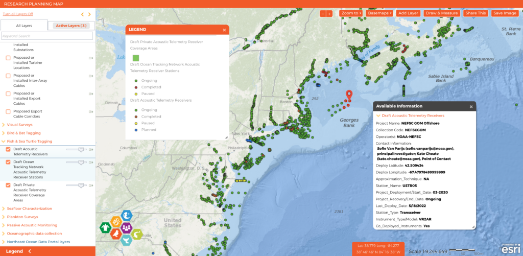
After nearly a year of work reaching out to over one hundred researchers and compiling information, RWSC released the first comprehensive map of acoustic telemetry receivers in U.S Atlantic (and some Canadian) waters. Led by the Protected Fish Species Subcommittee in collaboration with ROSA and ACT, the map shows over 5,000 individual receivers within the Atlantic Cooperative Telemetry Network, FACT Network, and Ocean Tracking Network as well as receivers from efforts that do not participate in regional networks. Clicking on each point reveals a project name, contact information for the project leads, deployment dates, information about other sensors deployed at that location, and links to the data held by the relevant telemetry network. The Subcommittee will continue to refine the map and visualization.

Acoustic Telemetry Data Management Best Practices
SOP for acoustic telemetry receiver operation
See below for additional information on each of the above recommendations.
Acoustic Telemetry Instrument Metadata and Tag Metadata Templates
We recommend all entities using acoustic telemetry as a method for offshore wind research or monitoring report instrument metadata and tag metadata using the templates provided by ACT. Reporting data in this standard format is the best way to ensure that all necessary metadata is captured and retained. It also allows for participation in regional collaborative networks and project interoperability, whether that be now or any time in the future.
Acoustic Telemetry Layer in the RWSC Research Planning Map
We recommend sending the completed Instrument Metadata form to [email protected] for inclusion in the Acoustic Telemetry Layer of the RWSC Research Planning Map. The Research Planning Map will display the locations of ongoing offshore wind research activities in U.S. Atlantic waters and provide users with access to contextual map layers and data that are available on the regional ocean data portals. The development of the map and initial set of data layers is funded by BOEM and is being conducted in collaboration with the Northeast Regional Ocean Council (NROC), Mid-Atlantic Regional Council on the Ocean (MARCO), and ROSA.
Inclusion of receiver locations on the research planning map results in less redundancy of receivers in the region. Awareness of nearby arrays reduces the inadvertent expensive duplication of receiver coverage and allows for informed planning of asset placement that leverages the existing network coverage. Widespread knowledge of receiver location also presents the opportunity to increase the longevity of deployments. While the map is not designed to be used as a safety tool, acoustic telemetry receiver deployments shown on the public Research Planning Map can improve navigational safety and reduce risk of conflict with other ocean users. Disruption of receivers is expensive to repair, causes data loss, and may reduce data quality.
Participation in Regional Acoustic Telemetry Networks
We recommend participating in the regional acoustic telemetry network for the study area (e.g., Atlantic Cooperative Telemetry Network (ACT), FACT Network, Ocean Tracking Network (OTN)). Participation involves submitting all completed data products and metadata forms (templates provided by ACT). Please visit the ACT Network’s Data Portal, MATOS (https://matos.asascience.com), for the mid-Atlantic and Northeast U.S. or FACT (https://secoora.org/fact/) for the Southeast U.S. for more information including User Agreements.
Regional acoustic telemetry networks provide data standardization and QA/QC services by acoustic telemetry data experts for all datasets in their network. This provides accuracy and consistency for researchers and analysts working with big datasets and saves time. This makes the data easier to use, and guarantees the data is stored somewhere other than a local drive, preventing accidental data loss. It also ensures that all data is standardized and analysis-ready.
Making Projects Publicly Available
We recommend setting projects to public once data and metadata are submitted to the appropriate regional acoustic telemetry network.
Publicly available projects allow for better science. Many marine species exhibit ranges and distributions that traverse human-made boundaries. For migratory, protected, and recreationally and commercially important species, tools that assess movement and presence/absence must be implemented at broad scales to accurately characterize animal distribution and potential range shifts, understand cumulative effects, and to separate these effects from other influences. Acoustic telemetry networks enable cooperative research for these species at broad scales.
Greater densities of strategically placed receivers in a cooperative network lead to greater potential statistical power and certainty in results/analyses, including better chances to detect cumulative effects and increase disentanglement of potential impacts of offshore wind development from climate change impacts. Without participation in a regional network, you may be unaware of where your tagged species move outside of your own receiver array.
It also allows more context for decision makers, elevates your project to a grander scientific landscape allowing decision-makers within your entity, regulators, resource managers, and many others, to understand your data and results in a broader context.
Please contact [email protected] with any questions or assistance implementing these recommendations.